Survival Lesson – Learning from Other People’s Mistakes
In almost anything in life, there are many ways to learn and improve, but probably one of the most effective and lasting ways is through trial and error. There is nothing like the proverbial 2×4 being cracked against your head to keep you from making the same mistake twice.
The same is true when it comes to wilderness survival, but the problem is that sometimes that mistake that you make might literally be your last. That’s why it is especially helpful (and far less painful or embarrassing) to learn from someone else’s mistake.
So, one great resource that I encourage to check out is the National Park Service Preventive Search and Rescue “Lessons form the Field.” With a very similar approach to how the NTSB studies plane crashes to help make the airline industry more safe, so does the NPS PSAR. Their blog is a collection of actual accidents that have occurred on federal park lands. What makes this blog special, though, is that the NPS expressly analyzes and critiques each event “in the hopes that readers can learn from the experiences of others.”
Here is an example which underscores how important it is to not only have a map and compass with you on your hikes but to be able to actually use it:
On Sunday, June 23, 2013, two friends, ages 40 and 38, set off an overnight backpacking trip at the Ten Lakes trailhead. Their destination for the night was one of the Ten Lakes, a six-mile hike. Of the pair, one lives in the Yosemite area and has some limited backpacking experience in the park, while the other had never before been on an overnight backpacking trip. Neither hiker had ever been on the Ten Lakes Trail. The local backpacker brought along a full-park topographic map (scale 1:80,000) that, though it included the area they would be hiking in, was not detailed enough for finding their way if they were to lose the trail. The local backpacker also was relying on his cell phone’s compass for any navigation the pair might need to do.
About two miles into their hike, and unbeknownst to the pair of backpackers at first, they lost the trail while crossing an open granite slab. When they looked behind them they noticed two more backpackers following them. They determined that these backpackers were also off trail, and continued to hike off trail even further. Eventually, they were in a wooded area where it was impossible to make out any nearby landmarks that would allow them to use their topographic map to figure out their approximate off-trail location. They also discovered that their cell phone compass wasn’t working, so they had no compass to help them determine a direction of travel. They decided to keep hiking, and for two to three hours, did not have any idea where they were. They debated between scrambling up higher to
get a vantage point and heading down toward Yosemite Creek; their plan changed frequently. As time passed and they didn’t seem to be any closer to finding the trail, the backpackers became increasingly concerned. When their cell phone compass finally began to work, they decided to make one last attempt to locate the trail to Ten Lakes (their other option, they had decided, was to try to head off-trail toward the trailhead and their parked car). When the compass did work, it was midday, with the sun directly overhead, and the backpackers discovered they were completely turned around, thinking that what turned out to be north was south; according to one of the backpackers, “While I have no way of knowing for sure, I believe we were going in circles.” Eventually, they saw another hiker in the distance, and quickly made their way toward the hiker, guessing that the hiker was on the trail, which turned out, luckily, to be the case. They were relieved, yet also tired from the stress of the past few hours; they were able to continue hiking to their planned destination for the night.
As a hiker, as soon as you realize you are no longer on a trail, and in the absence of a detailed topographic map and traditional (non-electronic) compass, it is important to stop immediately. You should observe your surroundings carefully and take note of landmarks, such as visible mountain tops, obvious creek drainages, and memorable trees and shrubs. You should then attempt to backtrack to the trail, even if it means going back uphill; be sure to frequently look back at the point where you discovered you had lost the trail to ensure you’re not becoming even more disoriented. If you can’t find the trail, return to the point where you realized you had lost the trail, sit down, and wait. As long as you told a friend or family member where you planned to hike and when you planned to return from the wilderness, you can rest assured that searchers will come looking for you. If, instead, you choose to continue hiking with no real hope of finding the trail, there is a good chance you are travelling farther away from your stated destination, making it more difficult for searchers to find you, and your chances of becoming injured while travelling off-trail, in unknown and possibly treacherous terrain, also increase.
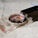
Always bring–and know how to use–a topographic map that will provide enough detail about surrounding terrain to be useful in the event you end up off-trail; for overnight trips into the backcountry, a 7.5-minute map, also known as a quad (scale 1:24,000), can be extremely helpful. Also critical for navigation is a traditional magnetic compass. A cell phone can prove unreliable to backpackers: the batteries can run out, rendering the device useless and reception in Yosemite’s wilderness is spotty at best, making it an unreliable tool for both navigation (the compass feature) and for communication (little to no reception).
When hiking in Yosemite, it is not uncommon for trails to pass over open granite slabs where it is often impossible to detect a trail tread. In these situations, stop hiking and gaze past the granite slab, sweeping the area with your eyes to discern where the trail continues. At times, other hikers leave stacks of rocks, known as ducks or cairns, to mark a route—do not rely on cairns to find your way. Cairns can often lead to a social (unofficial) trail or have been placed there by hikers who themselves didn’t know where the actual trail is.
The backpackers in this story were lucky that their cell phone compass worked long enough to orient themselves, and in the end they found their way. But, in reflecting on the experience and their overall preparedness for what seemed to be a simple, one-night backpacking trip, one of them commented, “I was totally unprepared. Our [water] filter was broken, I had no iodine. I was thinking, ‘Hey, we are going on a popular and marked trail, how could I get lost?’” In addition to the tips offered above, using the trip planning section on Yosemite’s official website could prove helpful when preparing for a trip into Yosemite’s wilderness.

———-
Would you like to learn how to use a map and compass? True North has an upcoming “Basic Wilderness Navigation” course so check out our Schedule to learn more.